
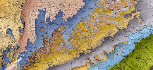
William Smith was an English geologist who created the first nationwide geological map of the UK. In 1815 Smith's beautiful geological map of Britain visualized geological types using different different colors.
William Smith's Maps allows you to explore William Smith's geological maps of England, Scotland & Wales in close detail. An interactive map interface allows you to view geo-rectified overlays of a number of William Smith's maps including his original 1815 geological map and his 1828 New Geological Map of England and Wales.
The interactive William Smith's Maps also includes a number of 3D fly-through movies of Smith's geological maps. In these fly-throughs William Smith's geological maps have been overlaid on a digital elevation model of the UK. The resulting movies help the user to appreciate even more the detailed beauty of Smith's 200 year old geological maps.
No comments:
Post a Comment